![](/images/other/stat-length.png)
![Trail Walking Longny les Villages - La Fonte - Malétable 7,8 km - Photo](https://media.geolcdn.com/t/1900/400/58715638-860a-4ade-9990-a9918a4f42a8.jpeg&format=pjpeg&maxdim=2)
La Fonte - Malétable 7,8 km
ODDAD78
User
![Length](/images/other/stat-length.png)
![Max alt](https://static1.geolcdn.com/siteimages/upload/files/1508320355ic_sort_altitude_max_24dp.png)
![Uphill gradient](https://static1.geolcdn.com/siteimages/upload/files/1508320355ic_sort_den_pos_24dp.png)
![Km-Effort](/images/other/stat-length.png)
![Min alt](https://static1.geolcdn.com/siteimages/upload/files/1508320355ic_sort_altitude_min_24dp.png)
![Downhill gradient](https://static1.geolcdn.com/siteimages/upload/files/1508320355ic_sort_den_neg_24dp.png)
![Boucle](https://static1.geolcdn.com/siteimages/upload/files/16400158638029165_repeat_loop_refresh_sync_direction_icon.png)
![Walking](https://static1.geolcdn.com/sitytour/trail-icons/101.png)
21m
Difficulty : Easy
![Scan this QR Code to open this trail in the SityTrail application](https://capi.geolives.com/qq0zvz2zws4bq2lad0pu/sitytour/trails/3079801/qr.png?size=200)
FREE GPS app for hiking
About
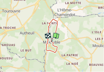
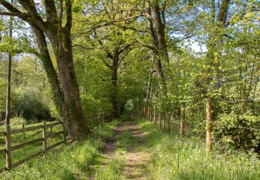
Trail Walking of 7.8 km to be discovered at Normandy, Orne, Longny les Villages. This trail is proposed by ODDAD78.
Description
Ce circuit emprunte pour partie le tracé du GR 22 et se partage avec des parcours VTT. Il est sans nul doute à anticiper un peu afin de le coupler à l'incontournable visite commentée de l'église et du clocher de Notre-Dame de la Salette (su réservation, au moins une semaine avant) !
Une pause gourmande pourra être anticipée puisque deux tables de pique-nique attendent les promeneurs au pied du lavoir rénové, situé sur le circuit, en face du lieu-dit "Le Moulin de Sévoux" !
Départ / Arrivée : Malétable
Communes traversées : Malétable, Moulicent, Tourouvre, L'Hôme-Chamondot
Prendre la D 289, direction Moulicent (se retourner pour apprécier la belle vue sur l'église Notre-Dame de La Salette)
Au hameau de la Travaillère, tourner à droite dans une chemin en herbe qui mène à un autre chemin : le suivre à gauche.
A la rencontre d'une voie communale, prendre à droite. Traverser la D 290 et prendre en face, direction le Mont Ferré. Avant la ferme, tourner à droite et emprunter une agréable chemin.
Arrivée à la D 291, prendre à droite jusqu'au Moulin de Sévoux (chambre d'hôtes aux nombreux labels de qualité). Deux tables de pique-nique, au pied d'un ancien lavoir rénové invite le promeneur à une pause gourmande !
Poursuivre par la droite, en montant par la D 290. Prendre à gauche le chemin de la vallée. franchir le ruisseau du Croustelle, puis bifurquer à droite. Le chemin se poursuit en sous-bois et débouche à la Fonte.
Tourner à droite , puis, 100m plus loin, prendre à gauche, et monter la côte.
A un carrefour en Y, prendre à droite, puis rapidement, prendre le 1er chemin à droite.
Sur la D 291, tourner à droite pour rejoindre le bourg. Vous pourrez deviner sur votre gauche de grands domaines privés (un château et le domaine de la Louvetière).
(Texte : https://rando-perche.fr/a-pied/la-fonte/)
Positioning
Comments
Trails nearby
![Trail Walking Longny les Villages - [Itinéraire] La Brisardière - Photo](https://media.geolcdn.com/t/375/260/19108d03-3d8a-43b4-b05b-172408edde68.jpeg&format=jpg&maxdim=2)
![Walking Walking](https://static1.geolcdn.com/sitytour/trail-icons/101.png)
Walking
![](/images/other/stat-length.png)
![](https://static1.geolcdn.com/siteimages/upload/files/16400158638029165_repeat_loop_refresh_sync_direction_icon.png)
![Trail On foot Longny les Villages - Attelage - Forêt et Panoramas - forêt de Réno-Valdieu - Photo](https://media.geolcdn.com/t/375/260/db99a0ed-9413-4500-8368-446623bccd86.jpeg&format=jpg&maxdim=2)
![On foot On foot](https://static1.geolcdn.com/sitytour/trail-icons/100.png)
On foot
![](/images/other/stat-length.png)
![](https://static1.geolcdn.com/siteimages/upload/files/16400158638029165_repeat_loop_refresh_sync_direction_icon.png)
![Trail Walking Feings - Perche-Le Valdieu - Forêt de Réno-Valdieu - - Photo](https://media.geolcdn.com/t/375/260/3680a9e7-0933-4c18-9cee-f8b32abef75f.jpg&format=jpg&maxdim=2)
![Walking Walking](https://static1.geolcdn.com/sitytour/trail-icons/101.png)
Walking
![](/images/other/stat-length.png)
![](https://static1.geolcdn.com/siteimages/upload/files/16400158638029165_repeat_loop_refresh_sync_direction_icon.png)
![Trail Walking L'Hôme-Chamondot - Traversées Percheronnes L'Home-Chamondot - La-Ferté-Vidame 20,4Km - Photo](https://media.geolcdn.com/t/375/260/775b310d-a192-48c6-b723-58a031dc55a1.jpg&format=jpg&maxdim=2)
![Walking Walking](https://static1.geolcdn.com/sitytour/trail-icons/101.png)
Walking
![](/images/other/stat-length.png)
![](https://static1.geolcdn.com/siteimages/upload/files/16400158638029165_repeat_loop_refresh_sync_direction_icon.png)
![Trail Walking L'Hôme-Chamondot - Traversées Percheronnes L'Home-Chamondot - Tourouvre 12,1Km - Photo](https://media.geolcdn.com/t/375/260/304fd560-c33e-465e-bfaa-960f3c968683.jpg&format=jpg&maxdim=2)
![Walking Walking](https://static1.geolcdn.com/sitytour/trail-icons/101.png)
Walking
![](/images/other/stat-length.png)
![](https://static1.geolcdn.com/siteimages/upload/files/16400158638029165_repeat_loop_refresh_sync_direction_icon.png)
![Trail Walking L'Hôme-Chamondot - Traversées Percheronnes L'Home-Chamondot - Monceaux-au-Perche 16,8km PROJET - Photo](https://media.geolcdn.com/t/375/260/e749965e-7201-4a20-b74e-2679c3909745.jpg&format=jpg&maxdim=2)
![Walking Walking](https://static1.geolcdn.com/sitytour/trail-icons/101.png)
Walking
![](/images/other/stat-length.png)
![](https://static1.geolcdn.com/siteimages/upload/files/16400158638029165_repeat_loop_refresh_sync_direction_icon.png)
![Trail Walking Longny les Villages - Longny-au-Perche (Longny-les-Villages) - Moutiers-au-Perche 13 km - Photo](https://media.geolcdn.com/t/375/260/994a1e71-8c6d-4d56-88cb-a3f14cc14c65.jpg&format=jpg&maxdim=2)
![Walking Walking](https://static1.geolcdn.com/sitytour/trail-icons/101.png)
Walking
![](/images/other/stat-length.png)
![](https://static1.geolcdn.com/siteimages/upload/files/16400158638029165_repeat_loop_refresh_sync_direction_icon.png)
![Trail Walking Longny les Villages - Longny-au-Perche (Longny-les-Villages) - Tourouvre 22 km - Photo](https://media.geolcdn.com/t/375/260/f6a882c6-7265-4c4e-81b2-b739ea6f09f8.jpg&format=jpg&maxdim=2)
![Walking Walking](https://static1.geolcdn.com/sitytour/trail-icons/101.png)
Walking
![](/images/other/stat-length.png)
![](https://static1.geolcdn.com/siteimages/upload/files/16400158638029165_repeat_loop_refresh_sync_direction_icon.png)
![Trail Walking Longny les Villages - Moulicent Vallée de la Jambée 3.6 Km - Photo](https://media.geolcdn.com/t/375/260/ext.jpg?maxdim=2&url=https%3A%2F%2Fstatic1.geolcdn.com%2Fsiteimages%2Fupload%2Ffiles%2F1553511878bg_sport_marche.png)
![Walking Walking](https://static1.geolcdn.com/sitytour/trail-icons/101.png)
Walking
![](/images/other/stat-length.png)
![](https://static1.geolcdn.com/siteimages/upload/files/16400158638029165_repeat_loop_refresh_sync_direction_icon.png)